MiFleet Logistics User Guide
Table of Contents
A. Logistics
A. Required Services
B. Preparation
C. Measurement System
D. History Period
III. Access Rights and Restrictions
A. Resource Rights Requirements
B. Units Rights Requirements
C. User Properties requirements
A. Interface Panels
A. Creating a New Order
B. Order Parameters
C. Maps
D. Custom Fields
E. Client Contact Details
F. File Attaching
G. Saving
A. Restrictions
B. Importing Dialog
C. Table of Orders
D. Table Editing
A. Logistics Services
B. Platform Integration
A. Planning Tab
B. Table
C. Map
D. Information Block
E. Filters and Dynamic Search
F. Sorting by Tags
G. Routes Building
H. Adding Orders to Route
I. New Unit Selection
A. Template Use
B. Creating a Template
A. Monitoring Routes and Deliveries
B. Working with routes
C. Displaying a Route on the Map
D. Information Block Usage
E. Multiple Operations with Routes
F. Unit Changing on the Route
G. Attached Files
A. Report Execution
B. Table Settings
C. Report Types
D. Planned and Actual Routes
A. General
B. Resource
C. Map Provider
D. Order Parameters
E. Import Orders
F. Units of Measurement
G. Warehouses
H. Attaching Geofences to Warehouses
I. Attaching Units to Warehouses
J. Deleting/Editing Warehouse
K. Planning
L. Distribution Optimization
M. Route Validity Parameters
N. Actions
O. Route Settings
P. Notifications
Q. Operator Notifications
R. Custom Fields
A. Logistics Mobile
B. Getting Started
C. Settings
D. Working with Logistics Mobile
I. Introduction
A. Logistics
- A multifunctional program created to implement control over all the working stages of a courier delivery service.
- Consists of a web and mobile application.
- The web app is developed to manage working processes.
a. These include order creation, distribution between units, route planning, optimization of routes, as well as monitoring and coordination. - The mobile app is developed to be used by couriers on both smartphones, and tablets.
a. The mobile app is intended to inform a courier about their job details; Orders attached, their sequence, and optimized delivery routes.
II. Preparation for Work
A. Required Services
- The application requires the “Orders” service to be activated.
B. Preparation
- For data to pass correctly from the web application to the mobile application, all the drivers, warehouses, and orders must be in the same resources.
C. Measurement System
- Applied depending on user settings. Can be Metric or Imperial.
D. History Period
- Depends on what is specified in the billing plan, or account settings.
III. Access Rights and Restrictions
A. Resource Rights Requirements
- View orders
- View geofences
- Create, edit, and delete orders
- Create, edit, and delete drivers
- Edit not mentioned properties
B. Units Rights Requirements
- View items and its basic properties
- Query reports or messages
- Use unit in jobs, notifications, routes, and retranslators.
C. User Properties requirements
- Can create items
- Can send SMS
- Can change settings
IV. Web Interface
A. Interface Panels
- Navigation
- Working area
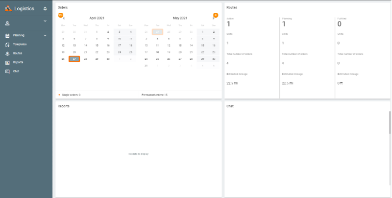
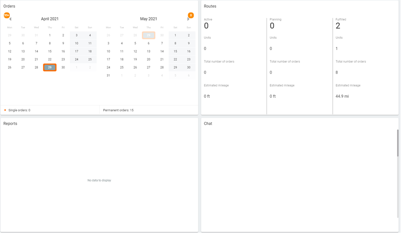
a. The working area features a dashboard which presents summary information and helps to quickly navigate between tabs. There are four sections.
1. Orders – Summary information on the days in which there are undistributed orders.
2. Routes – Summary information about active, planning, or fulfilled routes.
3. Reports – Displays statistical information on the last executed report for the previous day.
4. Chat – Shows a list of drivers. If a message comes in from a driver, their name is highlighted and an orange numeric indicator at the end shows the number of unread messages
V. Orders
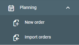
A. Creating a New Order
- Select New Order from Planning in the navigation panel.
- This window will contain five blocks: Order parameters, map, custom fields, client contact details.
B. Order Parameters
- Order Name – Arbitrary name used for order registration in the system. This is an obligatory field.
- Type – Two types of orders (single or permanent).
a. Single – Intended for single use.
b. Permanent – Intended to be used several times. After execution, they will not be moved to history - Address – Delivery destination point. Before entering this field, it is recommended to choose an address provider from the settings section. This is an obligatory field.
- Cost – Total cost of goods in the order.
- Radius (m) – Maximum distance on which a unit should come close to an indicated delivery destination point. Stopping here will allow the courier to confirm or reject an order by setting the corresponding status in the app.
- Weight (kg) – The overall weight of goods in the order. This value can be considered upon distributing orders among units.
- Volume – Any conventional value (such as items).
- Delivery interval (from – to) – Date and time interval for an order to be delivered. Pick dates in the calendar. Indicate initial and final dates of an interval. If an interval consists of a single day, then indicate it as both initial and final date of an interval. Click one of the fields of a delivery interval to open a calendar.
- Vehicle type – Preferable vehicle type for order delivery. This value is considered upon distributing orders among units. Dropdown list contains only vehicle types indicated for units in the monitoring system.
- Unloading time (min) – Approximation of how long it takes to unload goods.
- Priority – Numeric value from 1 to 99 rating the importance of an order’s distribution.
- Not to confirm orders outside the radius – If activated, this will force the driver to only be able to confirm the order from within the specified radius from the place of delivery.
- Comment – Arbitrary comment regarding a delivery.
- Tags – Key words based on which orders can be sorted. To add a tag, click the field, enter a key word, and use enter to define.
C. Maps
- 1. The address indicated in the order parameters is shown on the map by a marker. If necessary, a delivery destination address can be adjusted by dragging the marker to a corresponding point on the map. A necessary destination address can be added directly from the map.
D. Custom Fields
- Used to fill in custom fields created in the settings on the settings tab. You cannot edit the names of these fields. If you would like to delete these custom fields, this must be done in settings.
- If you fill in a custom field in the order and then delete the field in the settings, the indicated value is saved in the order. To delete this value, point to the line with the field and click the trash can icon.
- The values of custom fields are displayed in the following location.
a. Table on the planning page.
b. Report with detalization.
c. In the mobile application if the corresponding option is activated in settings. - There is a slider bar in the individual custom fields.
E. Client Contact Details
- 1. Includes the client’s name, phone number, and the e-mail.
a. Phone numbers and emails that are used to inform a client on a courier’s arrival.
b. Contact details are displayed for a courier in the mobile application.
F. File Attaching
- Orders can be attached with a file. The attached file can be viewed by a courier in the mobile application.
G. Saving
- Once the “Save” button is clicked, the saved order is moved to the planning section.
VI. Import Orders
A. Restrictions
- The number of orders in a file should not exceed 1000.
- If an order has not been imported, a corresponding notification appears.
- Important an order requires the file to be a .csv in UTF-8 coding, or an .xlsx file. These types of file may contain several orders simultaneously.
B. Importing Dialog
- To import an order, choose the planning section and click import orders.
- The importing dialog will appear in the right panel. This dialog provides the possibility to attach a file containing orders and create a template which can be used for file as a header.
- For imported files to be correctly recognized by the system, the template should possess the same sequence of parameters as an attached file.

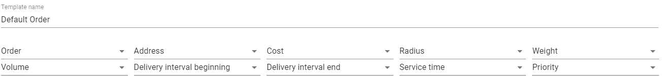
- The file must contain columns with the following information.
a. Address information.
1. Can also contain latitude and longitude coordinates.
b. Delivery interval.
C. Table of Orders
- All the orders the file contains are placed in the table of orders.
- If the file contains column names, these will be displayed in the first line of the table. Use “exclude first line” to omit names.
- If importing for the first time, or without a template, manually select the names for the columns in the drop-down lists. Save these selected names as a template and continue to use them when importing orders from similar files.
- If custom fields have been created you can use their names as column headings.
- If the table contains orders with incorrect data, their rows are colored red and placed at the beginning of the table.
- If the imported file does not contain a data column, the times specified in the General tab is automatically indicated in the column.
- If Not to confirm orders outside the radius option is switched on, it will also activate for all imported orders.
a. This will only apply to all imported orders if selected in “order parameters” under the General tab.
D. Table Editing
- Click a field of the table to edit.
- Editing a field will automatically save upon switching to another field.
- You can also edit multiple lines where similar information should be provided.
- You can use the “Undo” button up to 5 steps back.
- Buttons for editing the table contents are as follows.
a. Add template – Save a current header of the table as a template.
b. Add new column – Add new column to the table (max: 19)
c. Undo – Move a step back in case of editing mistakes. (max: 5)
e. Cancel – Cancel orders import.
f. Save – To save imported orders. (saved orders are moved to the planning section.) - Date and time format is indicated under settings. To import correctly, the date and time format should be the same.
VII. Integration
A. Logistics Services
- A service intended to automate the processes of import supported in MiLogistics.
- This service provides you with a possibility for importing multiple orders or routes from CSV, XLSX, or JSON.
- This also provides you with the possibility to integrate with either third-party services or ERP systems via special API for importing orders and routes.
B. Platform Integration
- You can edit the unit properties of a unit to change the capacity and volume.
a. First, go to the unit’s properties and select the “Profile” tab.
b. Find the “Cargo parameters” section.
c. You can edit the carrying capacity, dimensions, effective capacity (volume), and define vehicle weight and axle amount.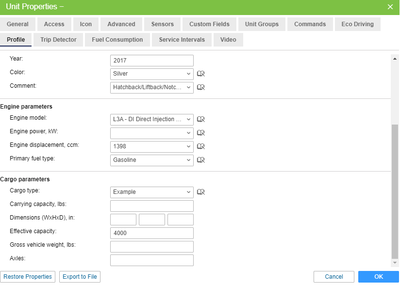
VIII. Planning
A. Planning Tab
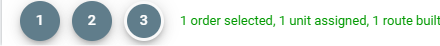
- Includes several steps
a. Choosing orders.

b. Choosing transport.
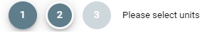
c. Route building.
- Notable peculiarities
a. Route building parameters can be changed from the planning section under the gear button.
B. Table
- Main actions for delivery planning is performed here.
- The planning step is shown in the lower left corner of the table.
- Additional order actions
a. Edit – Change order parameters
b. Copy – Create new order with identical parameters.
c. Delete – Delete order from system. - You can select multiple orders using the Ctrl key.
C. Map
- Information presented in the table will be visualized on the map.
- You can expand the map by using the four arrows soft button.
- Hover the mouse over particular elements to view tooltips.
- Holding ctrl while clicking an element will select the element.
D. Information Block
- Divided into three categories
a. Information on the chosen element
b. General information on orders
c. General information on routes
E. Filters and Dynamic Search
- Items shown in this table are determined by the filters that are applied.
- Filters are used to quickly find necessary items in the left panel.
- A calendar is used to select a delivery interval. The bottom of the calendar offers a drop-down list of fixed time periods.
- Orange dots on the calendar indicate the availability of single orders on a certain day. Their number is displayed to the right of the drop-down lists.
F. Sorting by Tags
- Orders can be sorted by custom tags, or by Warehouse tags.
G. Routes Building
- The color of routes can be changed under the General tab of settings.
- Optimal route building relies on the algorithm to consider parameters such as delivery interval, weight, and volume of goods.
a. Warehouse working hours and unloading time can also be accounted in routing if defined in the Warehouses tab. - To view a sequence of delivery points to be passed, expand a route.
- Points can be changed in order by using the Optimize button.
- You can manually reestablish delivery points by dragging and dropping. You can exchange delivery points from one route to another.
H. Adding Orders to Route
- Select the route you would like to add an order to. Press the checklist button un the lower part of the information block.
- This will open a dialogue with the name of the route and list of current open orders on it.
a. You can change the sequence of orders from here. - The delta of the modified arrival time for the moved orders is shown in red when it is increased and in green when it is decreased.
- Click Save to confirm new changes.
I. New Unit Selection
- To select a new unit for a route, hover the mouse of the route you would like to change and click the button with two cards, and two arrows.
- A table with available units will be presented.
a. Units that have at least one trip scheduled for a stated time are not shown. - Click save to confirm the change.
IX.Templates
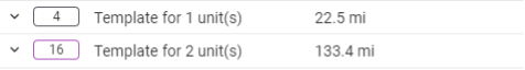
A. Template Use
- This is where you can find stored templates for creating routes.
B. Creating a Template
- Creating a report template
a. Mark the required permanent orders and activate the templates creation option in the calendar under the planning tab.
b. Click OK, then select the necessary units and click route templates to save.
c. The created template will appear on the templates tab. - Working with Templates
a. Templates can be edited, deleted, as well as have new units assigned to them.
X.Routes
A. Monitoring Routes and Deliveries
- Routes are displayed in the table according to their filter state chosen in the navigation panel.
- You can use the dynamic search in the navigation panel based on current table data.

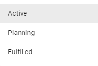
- “Active” route has the following properties.
a. The route until the first point of which remains the time indicated in the advance time field.
b. The route that has at least one point with confirmed status. - “Planning” route is a route where the activation time has not yet come.
- “Fulfilled” route has the following properties.
a. The route in which all orders are visited, or the status is set for all orders.
b. The route completed according to the auto completion settings. - Information for fulfilled routes will be displayed for 24 hours. Afterwards they will automatically be moved to history.
a. Historical routes can be viewed from reports.
B. Working with routes
- Active routes are shown in the table by default. Upon clicking the route’s line, a route’s fulfillment icon becomes active, a corresponding route is displayed on the map, and the map is centered and scaled in a way that all delivery points get into vision field.
- Clicking the arrow on the leftmost side of a route, the list of delivery points will be displayed.
a. This will not center or scale the map.
b. You can reorganize delivery points from this screen. - Route lines will be color coded as drivers make their stops.
a. The route line of a point a unit is moving toward will be marked by a green dot in the routes.
1. If one unit is assigned to multiple routes, the nearest (timewise) point is marked. - Two types of values are displayed
a. Arrival Time
b. Mileage - Arrival Time and Mileage will update from estimated values to actual values as delivery points are made.
a. Actual values will be shown in a slightly brighter color. - Routes will use the unit’s name by default for each title. You can change the title by clicking the letter “A” and bracket button on the bottom of the screen.
- Use the trash icon to delete a route from the list.
- During deletion or auto completion, if there is a non-visited order, they will not be removed, but instead copied to the same date and time if any can be found among single orders on the planning tab.
C. Displaying a Route on the Map
- A route chosen in the table will also show on the map.
- Actual routes can be displayed on top of planned routes.
a. Actual routes will appear as a solid line.
b. Planned routes will be displayed by a dotted line. - To switch between the two types of routes, use the icon in the top right of the map.
D. Information Block Usage
- Without any routes chosen in the table, the information block will show general data about routes.
- Current data on a chosen route is shown if a route is selected.
a. Includes name of unit, number of orders in route, estimated and actual route duration, estimated and actual mileage, driver name, time of route auto completion, and sequence in which orders should be visited.
b. A chat option is available here to speak with the driver, as well. - This information can be exported into .xlsx or .pdf formats.
E. Multiple Operations with Routes
- You can use the check box on the left of the route list to select multiple routes. You can select all routes in a list by selecting one while holding the ctrl key.
- You can open all selected routes at one time. This will also populate the map section.
- If more than one route is selected in the table, the sum data of each of them will be displayed in the information block.
F. Unit Changing on the Route
- Use the two cars and two arrows button to switch which unit is using a route.
G. Attached Files
- Couriers can supply an electronic signature when setting an order status.
XI. Reports
A. Report Execution
- Parameters must be specified in the navigation menu before executing a report.
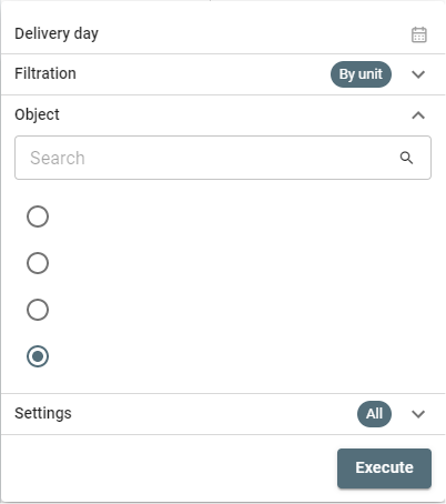
a. In the report type field, select the object basis of which the report should be executed: unit, driver, unit group, or driver group.
b. In the settings field, select the orders you would like to be included in the report.
c. In the choose object field, select the object for which you would like to apply the report to.
d. In the delivery day field, indicate the period for which the report should be generated.
1. You can use a quick interval or specify using the calendar.
e. Click OK.
B. Table Settings
- You can select which columns to include in a report by clicking the paper and pencil button.
C. Report Types
- Basic Report
- Detailed Report
D. Planned and Actual Routes
- Routes stored in history will provide users with a comparison option.
- Point to a route line and select the map pin icon to use it.
- Route information displays the following information.
a. Unit name
b. Number of orders in the route.
c. Estimated and actual route duration.
d. Estimated and actual mileage of the unit after visiting all points of the route.
e. Cost, weight, and volume of goods in all orders of the route. - The number of route points on the map correspond to the order in which they are visited.
- If you select a route point, the following information is displayed.
a. Warehouse or order name,
b. Warehouse working hours, or delivery interval.
c. Estimated arrival time.
d. Actual fulfillment time.
e. Estimated mileage.
f. Warehouse or order address.
g. Comments from courier.
XII. Chat
A. Supports communication between the dispatch and drivers.
B. Supports image viewership on the web application.
XIII. Settings
A. General
- Here you can find parameters used upon orders creation, distribution, and the routes involved.
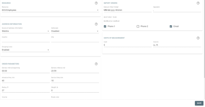
B. Resource
- The resource chosen here is where orders are created. By default, the user created resource will be selected. If there is no user created resource, the first one in the list will be chosen.
C. Map Provider
- For MiFleet, WebGIS is used.
D. Order Parameters
- These include the following.
a. Time from, time to, advance time, unloading time, radius, weight, volume, route color, not to confirm orders outside the radius.
E. Import Orders
- Used to set the parameters used in imported files.
F. Units of Measurement
- Indicates the cost currency unit, and the effective capacity unit.
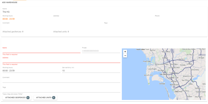
G. Warehouses
- You can create warehouses here by clicking “Add warehouse.”
a. Obligatory fields include the following.
1. Name
2. Addressb. It is recommended that special attention is paid to tags.
1. Order tags
2. Warehouse tags
c. At the first stage of planning, sorting by warehouse tags can be applied by enabling warehouse tags.
H. Attaching Geofences to Warehouses
- Geofences created in MiFleet can be attached to warehouses.
a. Selecting a warehouse and geofence in the filter will show orders located within the attached geofences.
I. Attaching Units to Warehouses
- Units created in MiFleet can be attached to warehouses.
a. Activating the attached units switch will display only units attached to a selected warehouse.
J. Deleting/Editing Warehouse
- To delete or edit a warehouse, click the context button and select delete or edit.
K. Planning
- Indicates parameters used as default algorithms in the planning section.
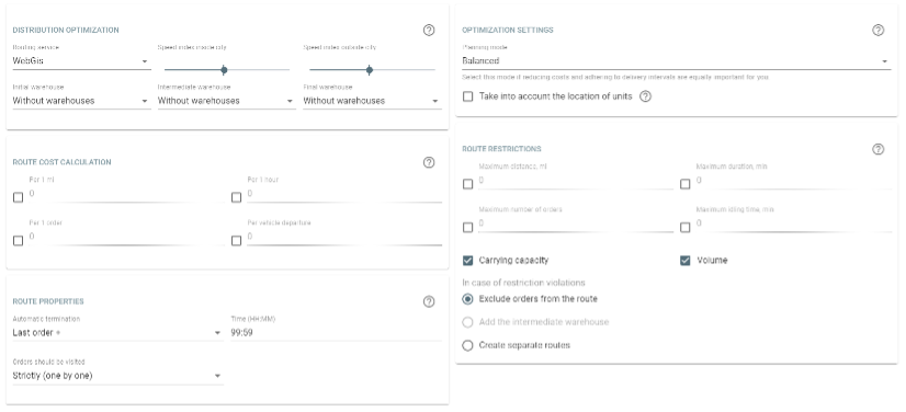
L. Distribution Optimization
- If no routing is chosen, you may use a vehicle’s average speed.
- Choose warehouses to be used in routes.
a. Initial Warehouse
b. Intermediate Warehouse
c. Final Warehouse
M. Route Validity Parameters
- Sets the parameters for a route that a unit following the route should meet.
a. Mileage, Duration, Orders, Idling, Carrying Capacity, and Effective Capacity.
b. You can also select the option “use optimal number of units.”
N. Actions
- Use Valid Route
a. Route validity parameters will not be exceeded when generating a route this way - Visit Intermediate Warehouse
a. Route validity parameters can be exceeded only if a visit to an intermediate warehouse is made. - Create Separate Routes
a. Parameter values can only be exceeded by creating a separate route.
O. Route Settings
- Route auto completion – The time when the route shoulder disappears from the list in Routes.
a. At certain time – The route will disappear from the list at a specified time.
b. Last order – Route disappears from the list after the last order is completed. - Orders should be visited – A sequence in which the orders of the route should be visited.
a. Arbitrary – Orders are visited in a free sequence. If the initial warehouse is specified, it must be visited first.
b. Strict – Orders are visited strictly in due course.
P. Notifications
- Client and Driver Notifications
a. Order Fulfilled.
b. Order Rejected.
c. Time left until delivery.
d. Order on the way
e. Distance to the delivery point - Notifications are sent automatically to the phone number or email when creating an order.
- To create a template, select “new,” the required notification type, specify additional parameters, and edit the text of the letter or SMS message.
- You can configure automatic push notifications to couriers using the app.
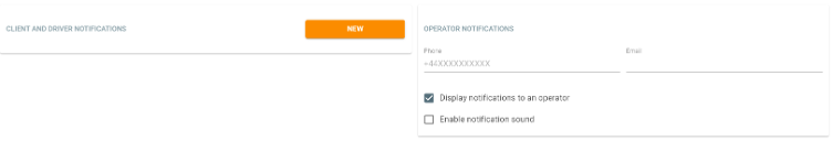
Q. Operator Notifications
- Notifications that are automatically sent to a driver or client. These can be duplicated for the operator.
- These can be created for the driver in the form of a push notification.
- For the client, these notifications can be a push notification, SMS, or an email notification.
- If the operator chooses so, they can disable or enable all notifications. They can also alter the sound upon reception.
- Click on the incoming notifications bell to view a list of notifications.
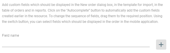
R. Custom Fields
- Used to create and delete the custom fields which should be displayed by default in all created orders.
a. These values can be indicated later. - Autocomplete Option
a. Used to automatically add all manually created custom fields. - Creating Custom Fields
a. Enter a name in the line and click the plus icon. Use drag and drop to alter the sequence. - Deleting Custom Fields
a. Use the trash can soft button.
XIV. Mobile Application
A. Logistics Mobile
- Monitor and track route completion.
- Access to attachments and comments for orders.
- Change the status of orders and sending comments or photos.
- Receive notifications for order creation or changes.
- Send location data of a driver or courier.
- Contact a client via phone call.
- Contact operator via chat function.
B. Getting Started
- First, use MiFleet to create a driver. Assign to the driver a unit.
- Fill out the phone number and mobile key fields under properties.
- Use the phone number and mobile key to log into the application.
- Click start.
C. Settings
- Here you can configure the map, enable notifications, enable tracker mode, and many other features.
- Tracker Mode
a. Activation and deactivation of the tracker in the mobile app. This is not yet available on MiFleet. - Map layer
a. OpenStreetMap, Google Roadmap, Google Satellite, Google Terrain, Google Hybrid, WebGIS - Photo Quality
a. Low (No more than 100kb)
b. Medium (No more than 300 kb)
c. High (No more than 600kb)
d. Original (No loss) - Notifications
a. Activation and deactivation of push notifications. - Admin Password
a. Creation and activation of a password for working with mobile application settings. - Help
a. User manual.
D. Working with Logistics Mobile
- Information on Routes and Warehouses
a. Displayed for route points without a status.
b. Includes the following.
1. Order sequence number or warehouse icon
2. Delivery interval or warehouse hours
3. ETA
4. Indicators of attachments and comments
5. Name and address of the order or warehouse
6. Estimated time and mileage between the route points. - Indicating Order Status
a. Tap the three dots in a line in the upper right corner to open a menu where you can confirm or reject an order.
1. You can also call the client here if a phone number has been provided. - Map
a. The map will automatically scale and center around an order once selected.
b. From here, you can track your own location, center the map on your location, or show the entire route.
1. Android will track the location of the unit to which a driver is bound. iPhones will track the location of the device from which the user has signed in.
c. You can view detailed order information from the map section as well. - Tracker Mode
a. Tracker mode is not available for MiLogistics currently. - The Logistics app is available on tablets. The general list of orders will not be hidden when displayed detailed order information.
